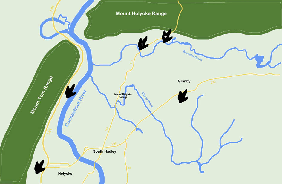
The above is a rough sketch of the area in Western Massachusetts where our dinosaur tracks come from. The dinosaur footprint graphics indicate approximate locations where dinosaur tracks have been found. There are many more locations on private land that we are not showing. While dinosaur tracks are common you cannot go to this area and expect to easily find them. For example, with all of the buildings and utilities put in at Mt. Holyoke College, and the fact that every time they dig there are experts looking to see what will be found, no dinosaur tracks have ever been found there. Tracks are most often found, and only in certain locations, when digging basements for homes. Typically heavy equipment is required to remove five to six feet of dirt and rock before tracks are found.
The footprint with the asterisk marks the Nash Quarry where our tracks come from. The footprint with the #1 marks the approximate location where the first dinosaur track was found by Pliny Moody in 1802. However, he did not record the location, other than to say it was found somewhere on his farm as he was plowing a field. The tracks Pliny Moody found can be seen in the track room at the Berneski Museum on the Amherst College campus.
Mud cracks are only found in the area between the Connecticut River and the Mount Tom Range. While tracks are plentiful to the east of the river, mud cracks generally are not found in this area. So we must ask the question, why not?
HOLYOKE BASIN GEOLOGY
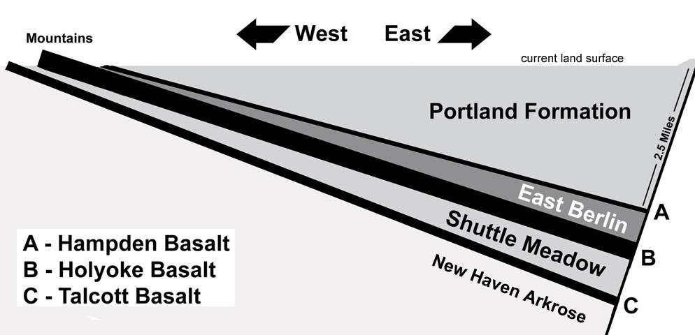
Geological Cross Section of the Valley
The Connecticut Valley is a half-graben rift valley formed as the continents broke apart. The term "half-graben" means that only one side of the valley sank, while the other side remained stationary, basically serving as a pivot point. The Connecticut Valley formed as the eastern edge sank.
The New Haven Arkrose was deposited before the valley started to form. As the eastern edge started sinking, the valley began filling with sediment. The layers of sediment tilted to the east as the valley continued to sink, and sediment continually was added. The continual addition of sediment resulted in the surface the dinosaurs walked on always being level. These sediment layers are named, Shuttle Meadow, East Berlin and Portland Formation. In addition, lava eruptions were spreading vast sheets of flood basalts across the new valley. When lava hardens to rock it is called basalt. There are three major layers of flood basalt in the valley: Talcott Basalt, Holyoke Basalt, and Hampden Basalt. These lava flows are part of what is thought to be the largest lava flow on Earth, the Central Atlantic Magmnetic Province (CAMP). The flood basalt was flat when deposited, but became tilted as the eastern edge of the valley continued to sink.
The above is a simplistic sketch, but it provides an overall idea of the geology of the valley. Notice the depth of the sediment. At it's deepest the Portland Formation is 2-1/2 miles thick. These are massive layers of sediment and basalt. However, on the western edge the sediment is very thin.
Based on evolutionary thinking the layers of sediment and flood basalt took millions of years to accumulate. However, using a Biblical time scale the valley would have formed and filled with sediment during the year of Noah's Flood. The hot flood basalts would have been quickly covered with wet sediment. And where the sediment was thin, along the western edge of the valley, between the basalt mountains of the the Mount Tom Range and where the river is now located, the heat from the flood basalt would have quickly dried the sediment leaving mud cracks. No sun required.
When a Biblical perspective is applied to what is observed, it all starts to make sense.
Go To Tour Guide Next - Ornithopod Tracks